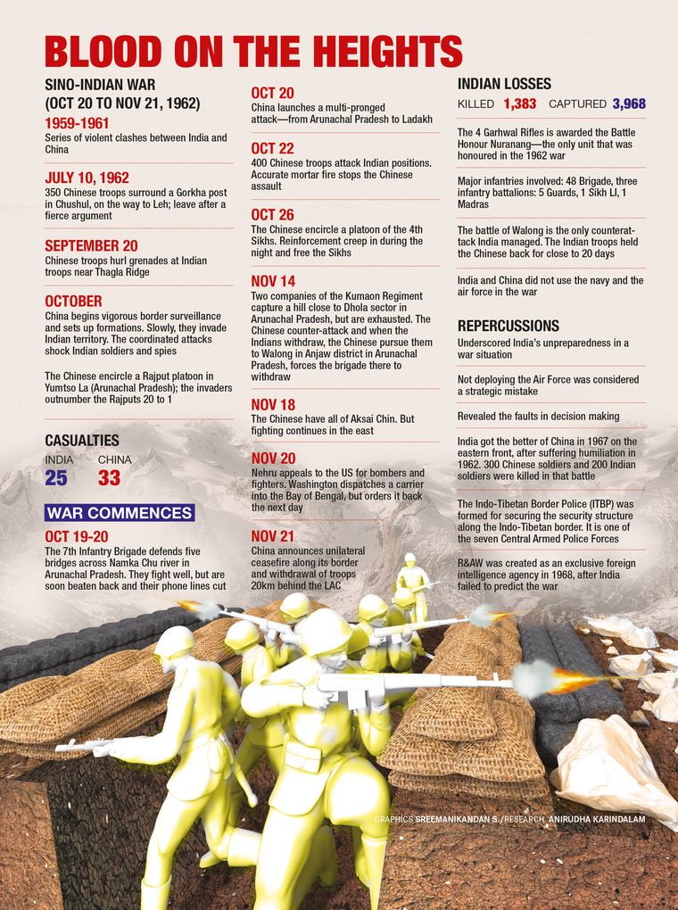
The Sino-Indian border dispute has had a profound impact on the contemporary history and evolution of the two Asian giants. Bilateral ties have an overarching impact on peace, prosperity and stability in the region, and perhaps the rest of the globe, too. It was over this problem that the two countries fought a brief but fierce war in October-November 1962. It continues to be the cause of skirmishes like the ones in Nathu La (Sikkim 1967), Galwan (Ladakh 2020) and Naku La (Sikkim 2020) and multiple standoffs between the two armies. The genesis of this boundary problem lies in a web of complex issues, fundamental among them being the partly un-demarcated, partly delimited and undefined, albeit traditionally accepted boundary of 4,057km along the Karakoram, Kunlun and Himalaya chain of mountains.
The major disputed territories are the Shaksgam valley and Aksai Chin (presently occupied by China), and an absurd and almost ‘fictional’ claim by China to a major part of Arunachal Pradesh. Besides these, there are four small pockets of disputed territory in areas such as Shipki La, Spiti, Barahoti and Lapthal, comprising 2,100sqkm. These are either passes on the Himalayan range or common pasturage on the Indian side.
Tibet has been India’s northern neighbour for centuries, until the Chinese invaded it in 1951. The geostrategic importance of Tibet in eastern Asia cannot be underestimated. “He who holds Tibet dominates the Himalayan piedmont; he who dominates the Himalayan piedmont threatens the Indian subcontinent,” wrote George Ginsburgs and Michael Mathos, in their 1964 book, Communist China and Tibet: The First Dozen Years. The British empire’s grand design was to retain Tibet as an autonomous buffer state and thereby keep at bay potential adversaries like Russia or China.
As far as the remote and mostly uninhabited Aksai China is concerned, it was controlled by the ruler of Hunza and its limits were vaguely known. The only historical records available of this area are from the British period, beginning from about the middle of the 19th century. At this juncture, the ‘great game’ between the Russian and British empires was at its peak. The northeastern limits of Ladakh kept fluctuating between two distinct strands of British strategic thought. The forward alignment which included the whole of Aksai Chin was proposed by W.H. Johnson, a geographer of repute, and Major General Sir John Ardagh, director of intelligence at the war office. The moderate and pragmatic boundary was put forward by George McCartney, the British consul-general in Kashgar, and Claude MacDonald, a soldier-diplomat posted in Peking. They recommended an alignment along the northern side of the Karakoram range that cuts across the Aksai Chin plateau and joined the Lanak La. This line gave the Chinese the whole of the Karakash valley and a large part of Aksai Chin; and with the approval of Viceroy Earl Elgin it was proposed to the Chinese in 1899. This boundary never received formal recognition by China, and on account of another bout of Russophobia, the British frontier reverted to the Johnson-Ardagh line during the term of Viceroy Lord Hardinge (1910-16).
The area from Lanak La to the Nepal border is thinly populated, unlike Aksai Chin. Hence there are records of trade between Tibet and Ladakh through well-known border passes like Shipki La, Mana, Niti and Taklakot which have been used for centuries by traders. Resolving the boundary issue in this sector, therefore, would not pose insurmountable problems and could be the first step of the boundary settlement.
The British delineated the boundary from Afghanistan to the Karakoram pass where the Chinese had constructed a frontier marker in 1892. This area was illegally ceded by Pakistan to China in 1963. Eastwards of the Karakoram pass, the boundary followed the watershed of the Shyok and the Yarkand rivers up to the formidable Kunlun range which has been the traditional southern frontier of China. However, this part of the boundary is not accurately recorded, and taking advantage of that, China has been shifting the limits of its frontier westwards from the late 19th century. Thus, the resolution of the boundary in this region is going to be a complex issue.
Aksai Chin and Lingzi Thang plains never experienced Tibetan or Chinese administration or permanent presence until 1951, making the Chinese claim to this area untenable. On the other hand, India possesses evidence of revenue collection and old records of this pasturage belonging to Tangtse tehsil of Ladakh district. Furthermore, at the time of India’s independence, the northern boundary from the Karakoram pass to Nepal was depicted in the maps by a colour wash, and the silhouette formed by the letters ‘Boundary Undefined’ followed the watershed principle and was also the traditional and customary boundary between Tibet and Ladakh and erstwhile Uttar Pradesh. Consequently, this became the basis of the boundary drawn by India in 1954.
Displaying scant regard to the boundary shown in Indian maps, the northwestern prong of the Chinese army’s offensive into Tibet in 1962 was unleashed from Xinjiang; it followed the ancient caravan route through Aksai Chin to reach Rudok and beyond in western Tibet. Chairman Mao Zedong’s command to his advancing armies was to build roads as they penetrated into Tibet and it took four to six years to be completed.
Prime minister Jawaharlal Nehru stated in Parliament on November 20, 1950, that “the frontier from Ladakh to Nepal is defined chiefly by long usage and custom”. Disregarding this, the Chinese decided to construct a strategic road from Kashghar through Aksai Chin as secretively as possible and forced the closure of the Indian consulate at Kashghar. Instead of robustly contesting this action, India simply acquiesced.
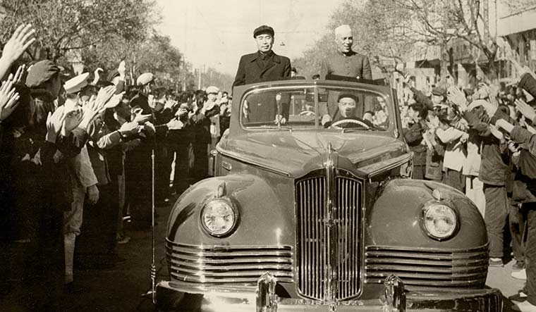
Nehru was without doubt a visionary statesman, but not a strategist; he was an idealist who was beguiled by the Chinese leadership. Ranged against him were committed communist leaders like Mao and Zhou Enlai. They were sworn proponents of a geopolitical strategy to regain all the ‘lost’ Chinese territories and ‘avenge the century of humiliation’. And Tibet, the low hanging fruit, was on top of the list.
Also read
- Revisiting 1962 war with China: When India's prestige was in a shambles
- How India handles China will determine success of foreign policy
- Had India employed its Air Force in 1962, there would have been fewer casualties
- There is no easy way for India to catch up with China
- War of 1962: How Kumaoni, Sikh, Gorkha soldiers fought back valiantly in Namti
Zhou told Indian ambassador K.M. Panikkar, ‘The privileges obtained as a result of the ‘unequal treaties’ forced by the British did not any longer exist.”He desired “fresh negotiations” to resolve trade and other issues with respect to Tibet. This led to the famous ‘Panchsheel’ agreement of 1954 wherein India sacrificed, on the ‘altar of peaceful coexistence and brotherhood’, all the privileges bequeathed to it, without any quid pro quo. When Nehru raised the issue of faulty depiction of the Sino-Indian boundary in Chinese maps with Zhou in 1954, he asserted that those were old Kuomintang maps and China did not have the time to ‘revise’ those. Astonishingly, Chinese maps published in 1956 incorporated even more areas of Ladakh within China. Strangely, this elicited an apathetic response among the political, civil and military leadership in India.
At present, the situation along the line of actual control (LAC) in Ladakh and other disputed areas remains tense and fragile. Despite prolonged military-to-military talks and diplomatic exchanges, the standoff in Aksai Chin area continues and China has not agreed to restore the status quo. China is very sensitive to any threat posed to its strategic artery and is palpably paranoid about India’s strengthening of the forward military and air base at Daulat Beg Oldi, including its connectivity by a road along the Shyok river.
Tibet is China’s vulnerable underbelly and it has historically failed to ‘Hanise’ Tibetans. Hence, ‘Tibet factor’ is one of the major issues impeding the improvement of Sino-Indian relations besides, of course, the boundary dispute. As a major conflict between India and China is no longer an option, maintenance of peace along the LAC (and its delineation) and negotiations at the military, diplomatic and political level, is an imperative to resolve the impasse. In fact, with the strong leadership that India and China have at present, a bold and mutually beneficial solution to the boundary can come about in the form of a high level ‘political coup’.
—The author is former chief of Army staff and governor of Arunachal Pradesh, and author of The McMahon Line: A Century of Discord.


