

What is happening at Joshimath is nothing new. For at least the last 25 years, Molta and Mahamolta―villages with a population of about a 1,000 people and about 25km from Joshimath―have been sinking. I visited these villages sometime back. People are mostly not aware of what is happening. This phenomenon gets traction only when there is loss or displacement because of it.
While the sinking (subsidence) has been going on for some time, it never happened at this scale; a large area is affected this time. Clearly, it is alarming as many houses are already damaged and have been rendered unsuitable for habitation.
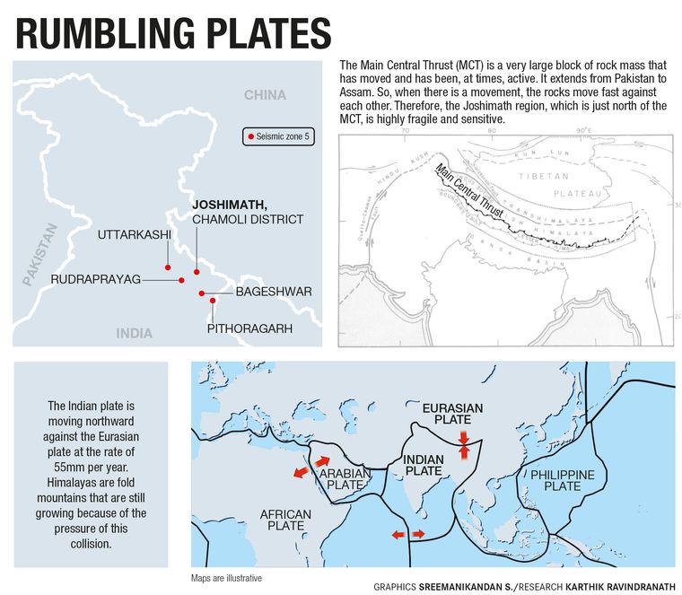
Joshimath is located in the higher Himalayan region and there is a tectonic line just to its south called the Main Central Thrust. The older rocks, forming the basement in the crustal profile, have moved because of the compression resulting from the northward movement and subsequent collision of the Indian plate with the Eurasian plate.

The Himalayas are young fold mountains and the tectonic dangers have to be kept in mind. The Indian plate is moving northward against the Eurasian plate at the rate of 55mm per year. There is a buildup and accumulation of a lot of stress and pressure which is sometimes accommodated by faults, thrusts and tectonic movements. This entire belt―Pithoragarh, Uttarkashi, Bagheshwar, Chamoli, Rudraprayag―falls in zone 5, the highest category of earthquake prone regions.
The thrust is a very large block of rock mass that has moved and has been, at times, active. It extends right up to Assam from Pakistan. It is a very big tectonic line. So, when there is a movement, the rocks move fast against each other along the fault lines. Therefore, the region is highly fragile and sensitive.
Joshimath had become a shelter for visitors right from the times of Shankaracharya (CE 8th century) who set up a math at Badrinath. But over time, Joshimath grew. The soil that covers the slopes of the Badrinath region are glacial and are deposits from ancient landslides. So, these are loose materials. Another cause for the presence of glacial material is that during the last glacial age many of the mountain areas had huge snow cover. Although the snow is still there, it is not permanent.
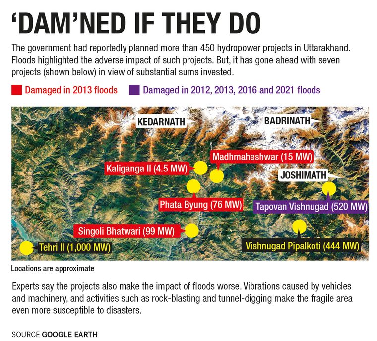
Year after year, buildings, power projects and even military structures have come up. Also, there is an increasing movement of tourists. The vibrations caused by vehicles and machinery moves through these fragile mountains and has made the area even more sensitive.
The slopes in the region are also steep. Joshimath slopes, for example, are bulging; they are convex. The already unstable slopes are slowly creeping down.
Moreover, Joshimath has no drainage management at all. The increasing water discharge and rain water is not properly disposed off. The water moves into the ground and as surface run-off, causing erosion. The percolating water moves through pores, fractures and joints. This movement is further triggered by the pore water pressure. Water goes into the fractures of the rocks, crevices and other places and creates tremendous pressure.
The water that is oozing out of certain areas is turbid and muddy because the sediment particles are more buoyant and behave like fluids. So, there is a lot of sinking. In other words, it is a disaster waiting to happen. Thank God it is not the rainy season.
Most significant is the heavy load on the slopes. You put a 5kg load on my back, I will be comfortable. But if you put a 50kg load, I will stoop and may even fall. The strength of the rocks is also reduced by water.
In 1880, there were 153 landslides in Nainital, which killed about 115 Europeans; local casualties may have been overlooked in the records. But, the British constructed 62 drains to dispose off the waste water. That is why Nainital is safe, otherwise the geology is fragile there, too.
So while evacuation and relocation is understandable in the short term, for the long term, we should have a complete plan for Joshimath that will address the slope problem, the geology, the bearing capacity of the rocks and drainage management. For that, technocrats, geologists and planners have to sit together.
My personal opinion is that new, small and smart townships with all modern amenities be raised, so as to ease the pressure from highly pressurised centres like Joshimath.
Most of the hill-stations were made by the British. After Independence, no new hill -cities have been made by Indians. So, we have to look for new sites where the rocks are sound and where the foundation is good. We cannot have large towns as the terrain has steep slopes and fragile systems.
After Joshimath, there is no notable human settlement till Badrinath. It is just the wilderness. So, in between, there are areas where such small townships can be built.
Nature always warns, but our memories are short.
The writer is retired dean of science faculty, Kumaun University, and has worked on the Himalayas for 45 years.
As told to Sanjib Kr Baruah