On August 9, Palestinian journalists decried Google Maps' depiction of the Isreal-Palestine area. Google had reportedly removed the name 'Palestine' from the area, demarcating the West Bank and Gaza regions as disputed territories.
In response, a Change.org campaign, called “Google: Put Palestine on your Maps”, was signed by more than 2,00,000 people. Palestinian Twitterati spoke out against it through #PalestineIsHere.
Google has just removed Palestine from its maps. But we will always resist and prove our presence 🇵🇸#PalestineIsHere pic.twitter.com/ISHYVYGxCj
— Rana (@ranaaa_d) August 9, 2016
However, reports state that this isn't a recent development. The name 'Palestine' has been missing from Maps for the past five months. Google has been accused of 'siding with Israel'.
Being a political issue, Google has mostly played it fair, marking disputed borders with dotted lines. In some cases, the maps are localised according to the region's politics. For instance, Chinese Maps users see Arunachal Pradesh as part of its territory, while it is part of India for Indian users.
More than 150 areas around the world are under territorial dispute today. Here are five major disputes that still cause political furore:
Aksai Chin and Arunachal Pradesh: India and China
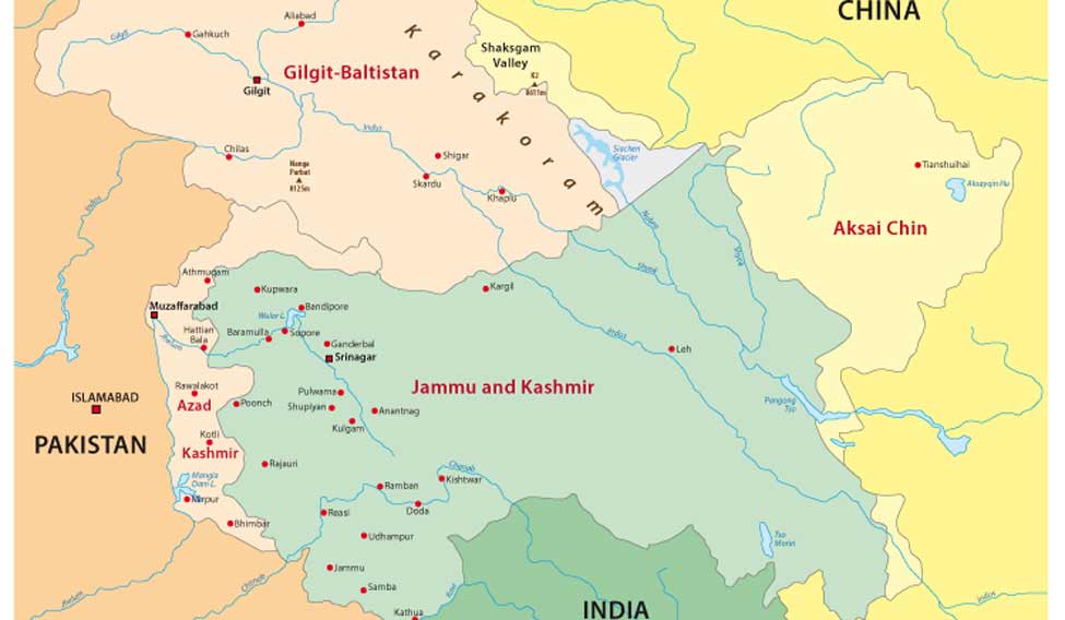
The situation: India has two major border disputes with China, Aksai Chin and Arunachal Pradesh. AP is under Indian government control, but China lays claim to it. Aksai Chin is claimed by India, but is controlled by Chinese administration. The Indo-Chinese war of 1962 sparked off when China constructed a highway across Aksai Chin. In 1996, the two countries established a Line of Actual Control. Indian and Chinese forces are still involved in skirmishes in both the regions.
Maps: China's Google Maps version includes AP and Aksai Chin in China. To India, AP is her northeastern-most state, while Aksai Chin is in Jammu and Kashmir. To the rest of the world, both the areas are demarcated as disputed territories. In 2009, India lashed out at Google when it 'accidentally' updated places in AP with Chinese names. It was immediately rolled back after issuing an apology.
Crimea: Tension between Russia and Ukraine
Google changes the names of cities and towns in the Russian Crimea.
— ☭Марина_Саакян☭ (@marina_saniram) July 28, 2016
Who gave such authority to Google ? pic.twitter.com/GoHriOrKTW
The situation: Crimea, south of Russia, has a population of 2.2 million. In 2014, Russia annexed the peninsula, and declared the country 'fully integrated into Russia' in 2015. However, Ukraine and many UN nations do not recognise this claim, and a fight over the region's sovereignty is still on. In 2015, Ukraine declared that Russia was occupying Crimea. Sanctions have been in place against Russia. Only Arabat Spat and the Syvash Sea regions of Crimea are still controlled by Ukraine.
Maps: In July 2016, Russia accused Google of changing names in Crimea in accordance with a diktat given by Ukraine to 'remove all Soviet symbols and names from Ukraine territory'. Google rolled back the change under pressure. In 2014, Google had marked Crimea as a disputed area. But Google Maps Russia marked it as part of Russia.
Kashmir: The raging India-Pakistan issue
How #diplomatic, eh @google?#maps #borders #india #pakistan #kashmir pic.twitter.com/iavNnpmiqK
— Tushar M (@QueersAXBorders) August 28, 2014
The situation: The 720-kilometre-long border line has been a cause of worry for the sister nations ever since they gained independence. Parts of Kashmir are occupied by each of the countries. According to the Indian government, about 60 per cent of the state is under Indian administration.
Maps: The entire J&K region is firmly within Indian territory, according to Google Maps India. But the rest of the world sees the border regions demarcated with dotted lines, including regions of Pakistan Occupied Kashmir, Gilgit-Baltistan and Azad Kashmir.
Senkaku Islands: claimed by China, Taiwan and Japan
The situation: The East China Sea dispute involves the Senkaku islands, a group of five islands stretched across seven kilometres, rich in oil reserves. In 1971, Japan took over administrative control of the region from the United States. This is disputed by China and Taiwan, claiming that the islands have been a part of the nations since the 1500s. This has led to rising tension among Asia's largest economies. Most recently, China encroached on the island's air space, souring relations with Japan.
Maps: In 2013, Japan noted that the disputed region had Chinese names on Google Maps, which was 'incompatible with Japan's stance'. Currently, the islands are named in accordance with all three countries: Senkaku for Japan, Diaoyu for China, and Diaoyutai for Taiwan.
Western Sahara: The Moroccan Wall
The situation: In Africa, Morocco took over former Spanish colony Western Sahara in 1975. The Polisario Front, led by native Sahrawis, fought for its liberation for 16 years. The 2500-kilometre Moroccan Wall cuts the region by half, separating areas controlled by Morocco from those under the Polisario. In 1991, the UN helped the two reach a truce. Morocco is yet to hold 'an agreed referendum on independence' of Western Sahara, and is the de facto administrator now.
Maps: In February 2016, Airbnb received flak for demarcating disputed territories wrongly. The company's map displayed listings in the Western Sahara as under Moroccan region. Google Maps, however, clearly indicates the border as disputed territory. Online petitions stating that there is no 'Western Sahara, only Moroccan Sahara' have come up in the past, asking Google to remove the demarcation.


